Introduction:
The hottest topic during the past weekend was BRI (Belt and Road Initiative) or OBOR (One Belt, One Road). Basically China's mega project of Belt and Road Initiative, connecting dozens of countries and building infrastructure with a "win-win" proposal.
One important part of OBOR has relevance to the Indian subcontinent. That is CPEC - China Pakistan Economic Corridor.
There are five parts to this writeup. Feel free to jump to any section that suits your interest as the writeup is quite long. If you have time, go through every section, including the videos and reading material links provided. You will need at least 5 hours to fully absorb the extensive research provided here, if you want to read and watch all the material provided.
Five parts in this writeup:
-----------------------------------------------------------------
Part 1: There are three general views about CPEC, from three concerned countries.
It does not matter if you support or oppose CPEC and OBOR. Just read to understand the ground realities and projections. Then give your opinion in comments, and specifically any corrections to the facts presented here.
-----------------------------------------------------------------
Part 2: Why do you say that a part of CPEC route is illegal as per international laws?
This is about the entry point of CPEC into Pakistan from China. The first 300 or so KM of CPEC passes through Jammu and Kashmir state, which is a legal part of India. You can refer to my earlier blog to learn about Gilgit Baltistan area - Jammu and Kashmir, a Reality Check. I have provided maps and much more details about the overall regions and the "dispute" part.

In short, neither China, nor Pakistan can ever claim that they OWN this Gilgit Baltistan area, which Pakistan also called as Northern Areas. If this area goes to international court, neither China, nor Pakistan can ever produce Accession document, which is with India for the entire Jammu and Kashmir state, of which Gilgit and Baltistan are part of.
Why so much emphasis on Gilgit Baltistan, a part of Jammu and Kashmir state in India?
For those who have not studied or watched Gilgit and Baltistan area of Jammu and Kashmir state,
there are some links here. It is a fabulously beautiful place on the earth!
Watch the first 7 minutes and the last five minutes. You will see how CPEC is building infrastructure in Indian territory occupied by Pakistan. In India this is called as Pakistan Occupied Kashmir or PoK for short.
Gilgit Baltistan is a paradise of Jammu and Kashmir lost by India. Illegally occupied by Pakistan and China (Shaksgam valley).
As part of the Sino-Pakistan Frontier Agreement from 1960s, the Chinese authorities guaranteed India that it accepted Gilgit-Baltistan as a disputed territory and that the agreement was only provisional in nature and would be renegotiated once the dispute of Jammu & Kashmir was resolved.
This is the main reason India is saying CPEC is violating its territorial sovereignty.
This is how the Karakoram map highway was built between 1960s and 1980s first, and then being widened and strengthened during 2010s. India has objected to this many times in the past.
K2, the world's second highest peak is legally inside India per accession documents, but illegally occupied by Pakistan. See how beautiful it is.
In short, Gilgit Baltistan is a paradise, a tough terrain and strategically very important for India, but under Pakistan and China's joint occupation now, as described above. This is the core issue for dispute and there is no way it would end anytime soon.
It's always a possibility that India can block international loans to CPEC tomorrow, citing legality of the territory. It's quite possible and a big risk Pakistan is taking knowing well the reality of Gilgit Baltistan's accession to India history.
-----------------------------------------------------------------
Part 3: Is CPEC really helpful for Pakistan? Let's examine Five big misconceptions.
For a minute let's say.. who cares about Indian opposition? Both China and Pakistan have nuclear weapons and there is no practical way India can wrestle Gilgit-Baltistan from Pakistan and China by force. India can play other tricks like water sharing cut off. But "we" can deal with them when they happen. "We" are going ahead with CPEC no matter what...
In that case, ask again. Is CPEC really helpful for Pakistan? This is the core question for this blog. CPEC is certainly helpful for China as it is planning it.
There have been many rationals provided for CPEC. Pakistanis think that it would upend sea route and CPEC would become primary supply route for Chinese goods and thus when it is completed then Dollars will flow through canals! First I demolish five misconceptions that people may have about CPEC, and then ponder on why it is being built, and its ramifications.
First misconception about CPEC: Cost of Transportation will become less
The first misconception is that it would become a supply route to China by upending sea route for goods supplied to and from mid-east. It is not so and I would try to prove it using approximations with data available from open sources.
Distance between Shanghai and Kashi (Kashgar) = 5121 KM.
Distance between Kashgar and Gwadar = 2747 KM.
Average Trucking cost per Ton per KM in China = 5 cents.
Average Trucking cost per Ton per KM in Pakistan = 1.8 cents.
These cost are from a decade ago, and would have become 6 cents for China and 3 cents for Pakistan, just by taking inflation into account.This is the most conservative calculation as I am not taking into account Hazard premium that nature of Terrain imposes on Pakistan (Karakoram Highway is rated world's fourth most dangerous highway) and the Hazard premium that China has to pay for transporting good through Takla Makan Desert, Kulun Shan mountains range and Altai Shan mountain range.
But still let us calculate cost of transporting a Ton of good from Shanghai to Gwadar.
Cost incurred in Chinese territory = 0.06 X 5121 = $307
Cost incurred in Pakistani territory = 0.03 X 2747 = $82.41
So total cost from Shanghai to Gwadar for a Ton of goods = $389.41
Now let destination port be Dubai.
Cost of Transporting Dubai to Shanghai = $820 per TEU.
Since standard 1 TEU = 21,600 KG, the Cost of Transporting 1 Ton via sea from Dubai to Shanghai = $38.
Cost from Karachi to Dubai for 1 TEU = $125 (rate for Gwadar are not available as port is not operational).
So the cost of transporting 1 Ton from Karachi to Dubai = $5.787.
Total cost of Shipping a Ton from Shanghai to Dubai via Gwadar = $395.
Total cost of Shipping directly from Dubai to Shanghai = $38 which is 10.4 times less than that of Transporting via Gwadar !!
And this is not all. CPEC passes through Khunjareb Pass which remain open only from May 1st till December 31st of each year. So CPEC can't be the main route to anywhere.
Second misconception about CPEC: China needs an energy Pipeline
The second misconception is that China is constructing a pipeline from Gwadar to Nawabshah. It has lead to Pakistanis speculating that Gwadar is on path of becoming an energy. Their TV shows even pulled in Iran and Russia into the gas equation of CPEC.
But it is not - reasons are here.
If one look at this map properly, China borders Gas and Oil rich Central Asia and has three mega pipelines running from Central Asia to China, including the world's longest pipeline.
Of
anything that China needs, the least thing that China needs in East
Turkestan is Energy. It could get ample amount of it just from across
the border, some 100's of KM away. Note that East Turkestan is referred by China as its Xinjiang province, but there is a lot of controversy around that involving the native inhabitants Muslim Uyghurs. This CPEC runs through Xinjiang province on the Chinese part.
Third misconception about CPEC: It saves time
The third misconception about CPEC is that it could save time. This again is false. Let’s assume the best possible conditions for a truck. A Truck would not stop anywhere (No rest for drivers, no checkpoints, no fuel or repair break) and assume that a Truck runs 24 Hours at 30KMph, and I am neglecting time it would be needed to transfer goods in Gwadar.
Time required for Travel = 262 Hours = 11 Days.
Via sea, the time required for transport of a container from Dubai to Karachi = 5 days.
So the total time required for overland transport when drivers and port handlers are supermen = 16 days.
Time required to transport a container from Dubai to Shanghai via sea = 15 Days.
This was an outlier calculation. Let's be realistic. Assume that a driver drives for 12 hour per day, it would take and on average take a day extra to go through customs and refueling stop. It would take him 91.57 hours to reach Kashgar, which would be equal to 7.7 days or 8.7 days taking pit stops into account. That Truck would take 170 Hours to reach Shanghai from Kashgar. That is 14 days of driving and assuming two days for pit stops, 16 days. We assume that Gwadar is as efficient as that of Karachi, it would take 6 days to clear import formalities.
Thus the total time it would need to transport goods from Dubai to Shanghai via Gwadar would be 36 days, compared to 15 days it would take to reach Dubai from Shanghai via Malacca!!
Fourth misconception about CPEC: It could serve Western China
There are two follies to this argument.
The first being that western China is sparsely populated and the second being that other seaports are closer to those provinces.
Following provinces are close to CPEC
1. East Turkestan (Xinjiang): Area 1664900 Sq KM; Pop 22.09 million.
2. Qinghai: Area 720,000 Sq KM; Pop 5.58 million.
3. Gansu : Area 425,800 Sq KM; Pop 25.64 million.
4. Inner Mongolia: Area 1183,000 Sq KM; Pop 24.82 million.
5. Tibet: Area 1228400 Sq KM; Pop 3.145 million.
Total area of these provinces = 5,222,100 Sq KM.
This is 54% of Total area of China, and an area 6.6 times that of Pakistan; while its population is just 81 million which is 6% of Chines population and less than half (0.44 times) of Pakistani population.
This is the extent of how sparsely populated Western part of China is.
Pakistan shares border with Takla Makan desert of China.
A Highway & Economic corridors brings prosperity when Economic
depression of a region is due to that region being cut off from rest of the country. In this case, underdevelopment is due to geographical factors, not due to infrastructure factors. See this map closely for climatic regions of Asian eastern half. Clearly a large portion of CPEC's intended area within today's China is BWk (Desert) or ET (Alpine) areas with very minimal human population.

Deserts, cold arid Plateaus, and mountains reduce your Economic potential (unless you harness them for tourism like Switzerland).
Now we come to aspect of distance between West Chinese cities and nearest seaports.
CPEC is not airdropping in Western Qinghai so that it would have same effect on all of Western China. It is joining China in North-West corner of China, that is the western corner of East Turkestan. The only provinces that it could affect are East Turkestan (Xinjiang) and its neighbours Tibet, Qinghai, Gansu in Western China, and Inner Mongolia in Northern China.
Many people would find it difficult to fathom that some provinces (mostly in West China) are many times larger than even Pakistan itself. East Turkestan is 2.1 times larger, Tibet is 1.54 times larger, Inner Mongolia 1.48 times larger Qinghai equal to Pakistan, and Gansu is half of Pakistan.
Eastern part of Western China is further away from Pakistan than even Europe. For example capital of Shaanxi (Taiyuan) is as far away from Islamabad by air (3559 KM) as Ankara (3600 KM).
CPEC could not be used by people separated by 2 provinces from Pakistan. It is a non starter.
But let’s present facts still.
All these Western provinces that Pakistanis dream Gwadar would serve are farther away from Gwadar than Western Europe is from Pakistan by Road. Distance between Islamabad and Berlin by road is 6353 KM, and of Paris is 7300 KM; nearly of the order of distance of Gwadar from any of Eastern provinces of Western China.
Anyway China does not even intend to use Gwadar for these provinces. It already has a corridor via Myanmar to Yunnan province for redundancy in 2013 itself.
Fifth misconception about CPEC: It would develop East Turkestan (Xinjiang)
Now we come to final dream of CPEC - that it would develop far west of China that is East Turkestan. This is pure day dreaming.
The reason that East Turkmenistan is not developed is because most of it is covered with Takla Makan desert. near Pakistan border and Tien Shan mountain range in the north.

Inner Mongolia region is not developed because most of it is covered with Gobi desert.

Quinghai is not developed because most of its is mountainous with Kulun, Altun and Bayan Har shan mountain ranges.
Gansu is not developed because its area is covered with Gobi desert and Quilian Shan mountain range.
Tibet is not developed because it is a barren cold plateau.
These places have a low population density because of geographical
limitations. Desert and Mountains never support high population, and this is a basic economic rule that low population areas never have high growth potential (because of less number of producers and consumers). Barring discovery of oil, desert remains
civilization backwater, irrespective of how many road you build since their population supporting capacity is limited by some very basic factors, FOOD and WATER. Even if you transport food at great cost in this area, you would still have no water to support a large settlement.
-----------------------------------------------------------------
Part 4: Then WHY is China financing such a massive CPEC project?
Now that we have put some misconceptions regarding CPEC out of way, we ponder on reasons why China is financing CPEC? There are four key reasons.
First reason for China building CPEC: Backup Trade route
The first reason is that China is building an alternative trade route in case Malacca and Sunda straits are blocked by US Navy or Indian Navy during a war. You need to go through either Malacca, Sunda, or Lombok straits, if you want to travel from Pacific to Indian oceans and does not want to swing around Papua New Guinea or Australia.
CPEC will provide China with alternative route, in case its sea trade is shut down by navies dominating the Indian Ocean.
Second reason for China building CPEC: Excess Built-up Capacity
The second reason for CPEC/OBOR is that China has excess capacity in Cement and Steel which it could not dump in market as most countries have started imposing countervailing duties on Chinese dumping. China is dumping its excess Steel and Cement capacity in OBOR, which the recipient countries have to pay. European investment into China has decreased recently. In 2016 it dropped 23% - lowest in 10 years. Chinese market access issues causing it. So China looking elsewhere to make profits.
Third reason for China building CPEC: Get Asian countries into Chinese debt
The third is strategic reason. China is trying to bind Asian countries to itself by investing in their infrastructure, investment that carry a steep rate of return, thus indebting them to China. This is not limited to Pakistanis as even Sri Lanka has $50Bn debt due to politically motivated Chinese investment in Hambantota done during Rajpaksa’s time, which it is finding difficult to discharge. Tajikistan is also facing a similar issue with big loans from Chinese.
CPEC plan made public: Nawaz Sharif's march towards turning Pakistan into Chinese province begins
Nothing much to gain for Pakistan. (A Pakistani TV debate): 104 Coal plants closed in China, but pollution would escalate in Pakistan. Then there is always the loan issue.
Fourth reason for China building CPEC: Sweet deal in Pakistan
The fourth reason is that China is getting a very sweet deal from Pakistanis for CPEC. See a number of news and analysis links here provided from Pakistani newspapers.
Chinese banks provide loans for CPEC, which is constructed using Chinese cement, steel, and manpower thus effectively returning that money back to Chinese economy.
Pakistan pays 2-5% interest rate above Libor (London Interbank Offered Rate), has taken sovereign guarantee for 18% RoR.
Pakistan would be paying China $90 billion on a loan of $50 billion!!! .. and that too when it has limited avenues to make money from CPEC,while dumping of Chinese goods would kill Pakistan industry. Pakistan also has to pay for ancillary expenditure like security from its pocket.
-----------------------------------------------------------------
Part 5: Finally, then WHY are China and Pakistan going ahead with CPEC?
From Chinese perspective, it is simple. It knows that Pakistan would not be able to pay its loan
and eventually China would come to own infrastructure and/or land inside Pakistan. It is classical neo-colonialism. Make a country so indebted to you that it could not help but sell itself to you. Pakistan would become a puppet of China completely :(
To this effect, China is also making Pakistan drive out any alternative creditors like ADB so that it does not have a competition in colonizing Pakistan.
Pakistan, on its part, is desperate for any investment, on whichever term it comes with. Pakistan's Military is getting a share, its people have a hope that CPEC would bring prosperity, and it also believe that if China own majority of assets in Pakistan, it would interfere in any future Indo-Pak war to save its assets.
If you have analyzed the analysis so far, you would be shaking your head stating - "It is hard to understand the mentality of Pakistanis.... also love the meticulous planning Chinese have done to reap a windfall in CPEC!"
Do you agree with the analysis? Tell me your feedback openly and in a civil way, by leaving a comment.
Thanks!
Bonus Material:
Some ancient Sanskrit names of some cities of East Turkestan or Xinjiang province of China;
Karasahr - Agnidesh
Khotan - Kustana
Aksu - Bharuka
Kucha - Kuchina
Kashgar - Sailadesha.
The hottest topic during the past weekend was BRI (Belt and Road Initiative) or OBOR (One Belt, One Road). Basically China's mega project of Belt and Road Initiative, connecting dozens of countries and building infrastructure with a "win-win" proposal.
One important part of OBOR has relevance to the Indian subcontinent. That is CPEC - China Pakistan Economic Corridor.
There are five parts to this writeup. Feel free to jump to any section that suits your interest as the writeup is quite long. If you have time, go through every section, including the videos and reading material links provided. You will need at least 5 hours to fully absorb the extensive research provided here, if you want to read and watch all the material provided.
Five parts in this writeup:
- General views from involved countries.
- Legality of a disputed area through which CPEC goes through.
- Misconceptions about CPEC in Pakistan.
- Strategic reasons for CPEC that would mostly benefit China only.
- Why both Pakistan and China are going ahead with CPEC?
-----------------------------------------------------------------
Part 1: There are three general views about CPEC, from three concerned countries.
- If you are a Pakistani, you will be talking about the bright future for Pakistan in CPEC and how Dollars will grow from trees in a generation! Of course, you will say Indians are jealous of Pakistan's upcoming massive development, and hence they are not joining OBOR or CPEC. By the way, CPEC is the largest investment promised to Pakistan since its formation in 1947!
- If you are an Indian, you will focus on Gilgit Baltistan area of Jammu and Kashmir state, that is legally a part of India, but illegally occupied by Pakistani. You will also focus on Shaksgam valley and Aksai Chin as related areas of Jammu and Kashmir, illegally occupied by China. And, CPEC will eventually touch these Pakistan and China occupied territories that are legally a part of India due to 1947 J&K accession document. For India, this is a clear violation of its territorial sovereignty.
- If you are a Chinese, you will talk about economic cooperation with all neighbouring countries, specifically linking Indian ocean with Pacific ocean with the great CPEC project and OBOR mega scheme. As a Chinese, you would say, keep politics out of economic project.
It does not matter if you support or oppose CPEC and OBOR. Just read to understand the ground realities and projections. Then give your opinion in comments, and specifically any corrections to the facts presented here.
-----------------------------------------------------------------
Part 2: Why do you say that a part of CPEC route is illegal as per international laws?
This is about the entry point of CPEC into Pakistan from China. The first 300 or so KM of CPEC passes through Jammu and Kashmir state, which is a legal part of India. You can refer to my earlier blog to learn about Gilgit Baltistan area - Jammu and Kashmir, a Reality Check. I have provided maps and much more details about the overall regions and the "dispute" part.
"The multi-billion dollar China-Pakistan Economic Corridor (CPEC) is being touted as nothing more than a 'black hole' as far as people of Gilgit Baltistan (shown in green in the map below) are concerned. Junaid Qureshi, a Kashmiri writer raises voice against the CPEC project, which passes through Gilgit Baltistan, a disputed territory controlled by Pakistan."

In short, neither China, nor Pakistan can ever claim that they OWN this Gilgit Baltistan area, which Pakistan also called as Northern Areas. If this area goes to international court, neither China, nor Pakistan can ever produce Accession document, which is with India for the entire Jammu and Kashmir state, of which Gilgit and Baltistan are part of.
Why so much emphasis on Gilgit Baltistan, a part of Jammu and Kashmir state in India?
For those who have not studied or watched Gilgit and Baltistan area of Jammu and Kashmir state,
there are some links here. It is a fabulously beautiful place on the earth!
Watch the first 7 minutes and the last five minutes. You will see how CPEC is building infrastructure in Indian territory occupied by Pakistan. In India this is called as Pakistan Occupied Kashmir or PoK for short.
Gilgit Baltistan is a paradise of Jammu and Kashmir lost by India. Illegally occupied by Pakistan and China (Shaksgam valley).
"China occupies more than 20,000 square kilometer of Gilgit-Baltistan (part of Indian state of Jammu and Kashmir) covering Shaksgam, Raskam, Shimshal and Aghil valleys" - Senge Sering, President of Institute for Gilgit Baltistan Studies.
As part of the Sino-Pakistan Frontier Agreement from 1960s, the Chinese authorities guaranteed India that it accepted Gilgit-Baltistan as a disputed territory and that the agreement was only provisional in nature and would be renegotiated once the dispute of Jammu & Kashmir was resolved.
This is the main reason India is saying CPEC is violating its territorial sovereignty.
This is how the Karakoram map highway was built between 1960s and 1980s first, and then being widened and strengthened during 2010s. India has objected to this many times in the past.
K2, the world's second highest peak is legally inside India per accession documents, but illegally occupied by Pakistan. See how beautiful it is.
In short, Gilgit Baltistan is a paradise, a tough terrain and strategically very important for India, but under Pakistan and China's joint occupation now, as described above. This is the core issue for dispute and there is no way it would end anytime soon.
It's always a possibility that India can block international loans to CPEC tomorrow, citing legality of the territory. It's quite possible and a big risk Pakistan is taking knowing well the reality of Gilgit Baltistan's accession to India history.
-----------------------------------------------------------------
Part 3: Is CPEC really helpful for Pakistan? Let's examine Five big misconceptions.
For a minute let's say.. who cares about Indian opposition? Both China and Pakistan have nuclear weapons and there is no practical way India can wrestle Gilgit-Baltistan from Pakistan and China by force. India can play other tricks like water sharing cut off. But "we" can deal with them when they happen. "We" are going ahead with CPEC no matter what...
In that case, ask again. Is CPEC really helpful for Pakistan? This is the core question for this blog. CPEC is certainly helpful for China as it is planning it.
- But for Pakistan? Is it worth the time, money, effort, international conflicts and much more?
- Beyond politics, loans, technology etc... the big question is.. is this CPEC making economic sense to Pakistan, where most of the things are being built?
There have been many rationals provided for CPEC. Pakistanis think that it would upend sea route and CPEC would become primary supply route for Chinese goods and thus when it is completed then Dollars will flow through canals! First I demolish five misconceptions that people may have about CPEC, and then ponder on why it is being built, and its ramifications.
First misconception about CPEC: Cost of Transportation will become less
The first misconception is that it would become a supply route to China by upending sea route for goods supplied to and from mid-east. It is not so and I would try to prove it using approximations with data available from open sources.
Distance between Shanghai and Kashi (Kashgar) = 5121 KM.
Distance between Kashgar and Gwadar = 2747 KM.
Average Trucking cost per Ton per KM in China = 5 cents.
Average Trucking cost per Ton per KM in Pakistan = 1.8 cents.
These cost are from a decade ago, and would have become 6 cents for China and 3 cents for Pakistan, just by taking inflation into account.This is the most conservative calculation as I am not taking into account Hazard premium that nature of Terrain imposes on Pakistan (Karakoram Highway is rated world's fourth most dangerous highway) and the Hazard premium that China has to pay for transporting good through Takla Makan Desert, Kulun Shan mountains range and Altai Shan mountain range.
But still let us calculate cost of transporting a Ton of good from Shanghai to Gwadar.
Cost incurred in Chinese territory = 0.06 X 5121 = $307
Cost incurred in Pakistani territory = 0.03 X 2747 = $82.41
So total cost from Shanghai to Gwadar for a Ton of goods = $389.41
Now let destination port be Dubai.
Cost of Transporting Dubai to Shanghai = $820 per TEU.
Since standard 1 TEU = 21,600 KG, the Cost of Transporting 1 Ton via sea from Dubai to Shanghai = $38.
Cost from Karachi to Dubai for 1 TEU = $125 (rate for Gwadar are not available as port is not operational).
So the cost of transporting 1 Ton from Karachi to Dubai = $5.787.
Total cost of Shipping a Ton from Shanghai to Dubai via Gwadar = $395.
Total cost of Shipping directly from Dubai to Shanghai = $38 which is 10.4 times less than that of Transporting via Gwadar !!
And this is not all. CPEC passes through Khunjareb Pass which remain open only from May 1st till December 31st of each year. So CPEC can't be the main route to anywhere.
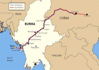
Second misconception about CPEC: China needs an energy Pipeline
The second misconception is that China is constructing a pipeline from Gwadar to Nawabshah. It has lead to Pakistanis speculating that Gwadar is on path of becoming an energy. Their TV shows even pulled in Iran and Russia into the gas equation of CPEC.
But it is not - reasons are here.
If one look at this map properly, China borders Gas and Oil rich Central Asia and has three mega pipelines running from Central Asia to China, including the world's longest pipeline.
 |
| This version of map does not show Indian borders accurately |
Third misconception about CPEC: It saves time
The third misconception about CPEC is that it could save time. This again is false. Let’s assume the best possible conditions for a truck. A Truck would not stop anywhere (No rest for drivers, no checkpoints, no fuel or repair break) and assume that a Truck runs 24 Hours at 30KMph, and I am neglecting time it would be needed to transfer goods in Gwadar.
Time required for Travel = 262 Hours = 11 Days.
Via sea, the time required for transport of a container from Dubai to Karachi = 5 days.
So the total time required for overland transport when drivers and port handlers are supermen = 16 days.
Time required to transport a container from Dubai to Shanghai via sea = 15 Days.
This was an outlier calculation. Let's be realistic. Assume that a driver drives for 12 hour per day, it would take and on average take a day extra to go through customs and refueling stop. It would take him 91.57 hours to reach Kashgar, which would be equal to 7.7 days or 8.7 days taking pit stops into account. That Truck would take 170 Hours to reach Shanghai from Kashgar. That is 14 days of driving and assuming two days for pit stops, 16 days. We assume that Gwadar is as efficient as that of Karachi, it would take 6 days to clear import formalities.
Thus the total time it would need to transport goods from Dubai to Shanghai via Gwadar would be 36 days, compared to 15 days it would take to reach Dubai from Shanghai via Malacca!!
Fourth misconception about CPEC: It could serve Western China
There are two follies to this argument.
The first being that western China is sparsely populated and the second being that other seaports are closer to those provinces.
Following provinces are close to CPEC
1. East Turkestan (Xinjiang): Area 1664900 Sq KM; Pop 22.09 million.
2. Qinghai: Area 720,000 Sq KM; Pop 5.58 million.
3. Gansu : Area 425,800 Sq KM; Pop 25.64 million.
4. Inner Mongolia: Area 1183,000 Sq KM; Pop 24.82 million.
5. Tibet: Area 1228400 Sq KM; Pop 3.145 million.
Total area of these provinces = 5,222,100 Sq KM.
This is 54% of Total area of China, and an area 6.6 times that of Pakistan; while its population is just 81 million which is 6% of Chines population and less than half (0.44 times) of Pakistani population.
This is the extent of how sparsely populated Western part of China is.
 |
| Chinese version of map does not show Indian borders accurately |
Pakistan shares border with Takla Makan desert of China.
 |
| Chinese version of map does not show Indian borders accurately |

Deserts, cold arid Plateaus, and mountains reduce your Economic potential (unless you harness them for tourism like Switzerland).
Now we come to aspect of distance between West Chinese cities and nearest seaports.
CPEC is not airdropping in Western Qinghai so that it would have same effect on all of Western China. It is joining China in North-West corner of China, that is the western corner of East Turkestan. The only provinces that it could affect are East Turkestan (Xinjiang) and its neighbours Tibet, Qinghai, Gansu in Western China, and Inner Mongolia in Northern China.
 |
| Source: Wiki |
Many people would find it difficult to fathom that some provinces (mostly in West China) are many times larger than even Pakistan itself. East Turkestan is 2.1 times larger, Tibet is 1.54 times larger, Inner Mongolia 1.48 times larger Qinghai equal to Pakistan, and Gansu is half of Pakistan.
Eastern part of Western China is further away from Pakistan than even Europe. For example capital of Shaanxi (Taiyuan) is as far away from Islamabad by air (3559 KM) as Ankara (3600 KM).
CPEC could not be used by people separated by 2 provinces from Pakistan. It is a non starter.
But let’s present facts still.
Take Shaanxi - Capital Taiyuan; Distance of capital from Islamabad = 4904.3 KM.
Distance of capital from nearest Chinese seaport (Tianjin) = 943 KM.
Distance of capital from Gwadar = 6644 KM.
Take Ningxia - Capital Yinchuan; Distance of capital from Islamabad = 4337 KM.
Distance of capital from nearest Chinese seaport (Tianjin) = 1200 KM.
Distance of capital from Gwadar = 6077 KM.
Take Chongquing (No capital); Distance of Chongquing from Islamabad = 5069 KM.
Distance of Chongquing from nearest Chinese seaport = 0 KM. This is considering the construction of Three Gorges Dam. Barring the largest cargo ships, ocean going ships could sail upto Chongquing. But still distance between Chongquing and Shanghai is 1689 KM.
Distance of Chongquing from Gwadar = 6843 KM.
Take Guzihou - capital Gulyang; Distance of capital from Islamabad = 5459 KM.
Distance of capital from nearest Chinese seaport (Beihai) = 796 KM.
Distance of capital from Gwadar = 7199 KM.
Take Yunnan - capital (Kuming); Distance of capital from Islamabad = 5859 KM.
Distance of capital from nearest Chinese seaport (Beihai) = 1024 KM.
Distance of capital from Gwadar = 7635 KM.
Take Sichuan - capital (Chengdu); Distance of capital from Islamabad = 4976 KM.
Distance of capital from nearest Chinese seaport (Chongquing) = 326 KM and (Shanghai) = 1968 KM.
Distance of capital from Gwadar = 6716 KM.
All these Western provinces that Pakistanis dream Gwadar would serve are farther away from Gwadar than Western Europe is from Pakistan by Road. Distance between Islamabad and Berlin by road is 6353 KM, and of Paris is 7300 KM; nearly of the order of distance of Gwadar from any of Eastern provinces of Western China.
Anyway China does not even intend to use Gwadar for these provinces. It already has a corridor via Myanmar to Yunnan province for redundancy in 2013 itself.

Fifth misconception about CPEC: It would develop East Turkestan (Xinjiang)
Now we come to final dream of CPEC - that it would develop far west of China that is East Turkestan. This is pure day dreaming.
The reason that East Turkmenistan is not developed is because most of it is covered with Takla Makan desert. near Pakistan border and Tien Shan mountain range in the north.

Inner Mongolia region is not developed because most of it is covered with Gobi desert.

Quinghai is not developed because most of its is mountainous with Kulun, Altun and Bayan Har shan mountain ranges.
Gansu is not developed because its area is covered with Gobi desert and Quilian Shan mountain range.
Tibet is not developed because it is a barren cold plateau.
 |
| Chinese version of map does not show Indian borders accurately |
-----------------------------------------------------------------
Part 4: Then WHY is China financing such a massive CPEC project?
Now that we have put some misconceptions regarding CPEC out of way, we ponder on reasons why China is financing CPEC? There are four key reasons.
First reason for China building CPEC: Backup Trade route
The first reason is that China is building an alternative trade route in case Malacca and Sunda straits are blocked by US Navy or Indian Navy during a war. You need to go through either Malacca, Sunda, or Lombok straits, if you want to travel from Pacific to Indian oceans and does not want to swing around Papua New Guinea or Australia.
 |
| Malacca, Sunda and Lombok straits of south east Asia |
CPEC will provide China with alternative route, in case its sea trade is shut down by navies dominating the Indian Ocean.
Second reason for China building CPEC: Excess Built-up Capacity
The second reason for CPEC/OBOR is that China has excess capacity in Cement and Steel which it could not dump in market as most countries have started imposing countervailing duties on Chinese dumping. China is dumping its excess Steel and Cement capacity in OBOR, which the recipient countries have to pay. European investment into China has decreased recently. In 2016 it dropped 23% - lowest in 10 years. Chinese market access issues causing it. So China looking elsewhere to make profits.
Third reason for China building CPEC: Get Asian countries into Chinese debt
The third is strategic reason. China is trying to bind Asian countries to itself by investing in their infrastructure, investment that carry a steep rate of return, thus indebting them to China. This is not limited to Pakistanis as even Sri Lanka has $50Bn debt due to politically motivated Chinese investment in Hambantota done during Rajpaksa’s time, which it is finding difficult to discharge. Tajikistan is also facing a similar issue with big loans from Chinese.
CPEC plan made public: Nawaz Sharif's march towards turning Pakistan into Chinese province begins
Nothing much to gain for Pakistan. (A Pakistani TV debate): 104 Coal plants closed in China, but pollution would escalate in Pakistan. Then there is always the loan issue.
Fourth reason for China building CPEC: Sweet deal in Pakistan
The fourth reason is that China is getting a very sweet deal from Pakistanis for CPEC. See a number of news and analysis links here provided from Pakistani newspapers.
Chinese banks provide loans for CPEC, which is constructed using Chinese cement, steel, and manpower thus effectively returning that money back to Chinese economy.
Pakistan pays 2-5% interest rate above Libor (London Interbank Offered Rate), has taken sovereign guarantee for 18% RoR.
Pakistan would be paying China $90 billion on a loan of $50 billion!!! .. and that too when it has limited avenues to make money from CPEC,while dumping of Chinese goods would kill Pakistan industry. Pakistan also has to pay for ancillary expenditure like security from its pocket.
-----------------------------------------------------------------
Part 5: Finally, then WHY are China and Pakistan going ahead with CPEC?
From Chinese perspective, it is simple. It knows that Pakistan would not be able to pay its loan
and eventually China would come to own infrastructure and/or land inside Pakistan. It is classical neo-colonialism. Make a country so indebted to you that it could not help but sell itself to you. Pakistan would become a puppet of China completely :(
To this effect, China is also making Pakistan drive out any alternative creditors like ADB so that it does not have a competition in colonizing Pakistan.
Pakistan, on its part, is desperate for any investment, on whichever term it comes with. Pakistan's Military is getting a share, its people have a hope that CPEC would bring prosperity, and it also believe that if China own majority of assets in Pakistan, it would interfere in any future Indo-Pak war to save its assets.
If you have analyzed the analysis so far, you would be shaking your head stating - "It is hard to understand the mentality of Pakistanis.... also love the meticulous planning Chinese have done to reap a windfall in CPEC!"
Do you agree with the analysis? Tell me your feedback openly and in a civil way, by leaving a comment.
Thanks!
Bonus Material:
Some ancient Sanskrit names of some cities of East Turkestan or Xinjiang province of China;
Karasahr - Agnidesh
Khotan - Kustana
Aksu - Bharuka
Kucha - Kuchina
Kashgar - Sailadesha.