Thursday, May 4, 2017

History of Bengaluru

There was a discussion.. Which languages did Bengaluru speak historically? Who built Bengaluru?

Since I am born and brought up in Bengaluru, I have seen right my childhood many languages and regions trying to “claim” that this city belongs to them :) So nothing is new in asking such things, but maybe this would give you opportunity to learn more on this amazing city of India that is contributing Lakhs of Crores towards India’s economy today, each year. 

Let me take you back a 1000 years and give a tour of Bengaluru's history.

Start with Gangas: Ganga (shown in the map below yellow region), was a formidable south Indian kingdom 1000 years ago. Their capital was initially north east of Bengaluru (Kolara) and then moved to south west of Bengaluru (Talakadu). History of Bengaluru starts with Ganga period.

Source: Karnataka Gata Vaibhava by Aloor Venkataraya.


Then came Hoysalas. The territory of Bengaluru was under Gangas till then, but no city or town was in place. About 900 years ago, Veera Ballala, the Hoysala King lost his way during a hunting expedition in today’s Bengaluru area. It was a semi forest then. An old lady cooked beans for the king and served the hungry man. He was so delighted that he called that place, Benda kaal-ooru in Kannada (ಬೆಂದ ಕಾಳ ಊರು), literally meaning in English, “the town/city of boiled beans”. That’s the most popular story of how the name got stuck. Later BendaKaalooru became Bengaalooru and then Bengaluru. All three have the same meaning in Kannada - the city of boiled beans.

Still it was nothing more than a small village then.

Then came Kempe Gowda 1. He was a paale-gaara (feudatory) of the mighty Vijayanagara kingdom,which was ruled from Hampi in the center of southern peninsula. Vijayanagara was the biggest Hindu kingdom of India 500 years ago. It’s capital Hampi was the richest city in India 500 years ago.. Maybe it was among the 5 richest cities of the world reading the chronicles of how they sold precious stones on street sides then. Vijayanagara was a Kannada and Telugu hybrid kingdom, with both languages passionately claiming the mighty Krishna Deva Raya - a good thing in India :) Maybe even Tulu people might join the claiming race soon! As you can see, Vijaya Nagara (City of Victory) occupied almost the entire south India, with extensions going into Goa and Odisha at the peak. And Kempe Gowda being a part of Vijayanagara rule, had his hand in the geographical center, including the future gold mine, Bengaluru.


Kempe Gowda built four watch towers marking the four boundary poles of Bengaluru.
  1. Lal Bagh in the south
  2. Kempambudi Kere (lake) in the west,
  3. Halasuru kere (lake) in the east, and
  4. Mekhri circle area in the north.
Today, Lal bagh still exists. You can go see the tower there. For the rest, you have to search a lot.
If you walked around the Pete (in Kannada pete - ಪೇಟೆ - means shopping area) area of Bengaluru three centuries ago, this is how you would have seen. Even today, most of these Pete’s exist, with many remarkably doing the same kind of business their great-great-great fathers did centuries ago!
Bale-pete means bangle market and Akki-pete means rice market. Every pete is either named after a commodity name in Kannada, or a community/caste that did business there. Uppara, Ganiga and Tigala are all community/caste names in Kannada. Today, the most famous police station near the central Majestic bus stand is Upparpete police station, retaining the historic name!


Then Bengaluru picked up growth well. A fort came up in the center. Got reinforced. Marathas had their share of building the city center. Hyder Ali and Tipu had their share of building. Some small villages that existed with Chola influence in the north East (near Halasuru) got absorbed into the main city. This area Halasuru derives name from Halasu + Ooru meaning the town of Jack Fruit trees. British pronounced it Ulsoor. By now it was a very cosmopolitan city with great weather, good commerce, well protected and many languages. So people started coming in from all corners as it was the geographical center of south India.

This was Bengaluru about 250 years ago. Today, this circle is within the central 25% of the city.

Source: How Kempe Gowda built Bangalore.

Kempe Gowda’s city was absorbed into Mysuru (Mysore as British called) kingdom ruled from Srigangapattana (later Mysuru). This was after Vijayanagara collapsed and Hampi was ransacked and pillaged by Sultanates of Deccan plateau. What started as a small Mysuru (in yellow below), grew in strength and peaked by 1782 when Hyder Ali had taken over from Wodeyar rulers. Hyder Ali was employed by Wodeyars, but he tricked his way into taking over a kingdom. At the peak of Mysuru, the boundaries reached well into today’s central Telangana, half of today’s Tamil Nadu, half of today’s Rayala Seema (AP) and northern Kerala. It did not however contain the northern edges of Karnataka, which were firmly with Sultans/Nizams of Deccan. Bengaluru started growing rapidly during this phase with palaces, forts, gardens, trade etc.


Pic source: Wiki (John Bartholomew and Sons. Edinburgh - Lewis Rice, Mysore Gazetteer, Volume I, Mysore in General, 1897)

Then Tipu died fighting the British in a series of wars at the end of 18th century. That was the biggest turning point for today’s Karnataka region. British divided the Kannada speaking areas into many dominions. They gave away the north western parts to Bombay (Marthas), North East to Hyderabad (Nizam), south west, south and south east to Madras (British). The might of Kannada empires since 4th century CE on the western part of south India collapsed. Mysuru became a landlocked dominion of the British empire and struggled over the next 150 years. Kannada speakers got spread out into multiple provinces/states losing unity and cohesion for the next 150 years. Since the original question was related to Tamil, you can see that today’s Coimbatore, Erode, Krishnagiri, Hosur, Palghat (Kerala now), Ooty etc. were all a part of Mysuru before British took them over, and merged with Madras. That was a big turning point in the history of south India, languages, rivers etc. Even the Mettur dam region in Tamil Nadu today, the biggest dam on Kaveri river, was a part of Mysuru kingdom a little over 200 years ago. Most of today’s south India’s river sharing, border overlaps, linguistic fights etc. have roots in that major surgery that British did.

 Source: The Tiger and the Thistle

Then what British did was to let Mysuru keep the Bengaluru city proper (the Pete area we talked about above). They build a big garrison and new cantonment in the north east of the city. They loved the weather of the city and lived in the cantonment. Since their capital was Madras in the south, they brought in lots of Tamil and Telugu people into the cantonment for various army and service related jobs. The oldest engineering regiment of Indian army today, is incidentally from the same cantonment area of Bengaluru (Madras Engineering Group), which is right next o Halasuru lake! The map below is from 1914, by which, the new MG Road had clearly divided the older Pete city of Bengaluru from the new cantonment area of Bengaluru.


Source: Baedeker Indien 1914 Maps

Then the city grew immensely after independence - primarily due to the availability of technical resources, education and great weather. Today, the city is the second biggest in India in terms of area (after Dilli/NCR, though they have multiple municipalities), having 198 wards. The older pete parts of the city are hidden in the central ward around 109 (Chikka pete). The cantonment area of British is around ward 90 (Halasuru). The city has grown on all 360 degrees, almost reaching Tamil Nadu at ward 192 and 191. In the north it is growing so fast now, that from the international airport in the north, you can travel to Andhra Pradesh border faster than the southern edge of the city!

 Source: Maps Of India


The city has grown so big today that you can almost walk to Tamil Nadu (Hosur) in the south East from ward 192 (Begur). It is just around 10 KM and in another 5 years, the city might actually grow right to Tamil Nadu border!

Hope this long explanation gave you a history of Bengaluru and Karnataka, how it got the name, historic pete parts that thrived for 400+ years, historic boundary, British arrival into cantonment, migrations and the 360 degree growth today.

In summary, Bengaluru has always been a Kannada speaking city since Kempe Gowda’s times. But it has absorbed Telugu, Tamil, Urdu, Malayalam, Marathi, Tulu, Konkani, Hindi and much more over the centuries. Today it has the largest population of migrants from North Eastern states in south India. I don’t remember ever from my school days long ago, when we had less than 5 languages in our class room :) During my college days, I remember just in 5 KM drive from Majestic to MG Road, I could see Kannada, Telugu, Hindi, English, Tamil and Malayalam movies in theaters, all running house full!

So it is a a city for everyone. Respect the diversity, respect the willingness of the city to absorb people from all corners of India, and still keep harmony for most part.

Enjoy :)

Why is Congress losing its ground in India?

There was a question on Quora:

Why is Congress losing its ground in India?
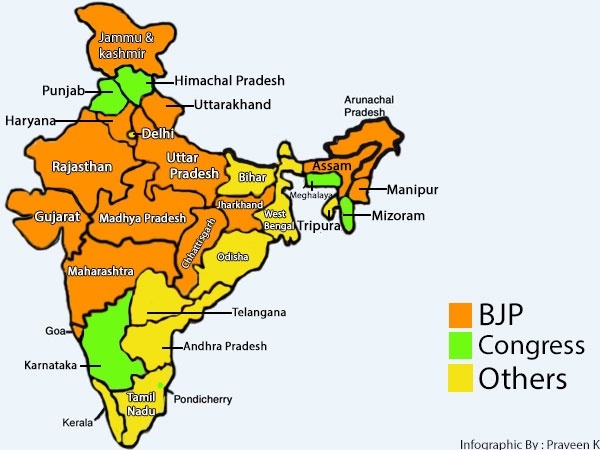
A cursory look at the political map of India reveals that the Congress rules some patches at the margins with only Karnataka, Punjab and Himachal Pradesh left as the proper in-land states..


I tried to answer with March 2017 current assessment of Indian politics. See if you agree with me.


Congress is losing during the 2010s mainly because of the following:

1) An ailing President, who does not give up the top post.
Sonia Gandhi has been the President of Congress for nearly 20 years now. By far that is the longest stint in Congress party’s history, even if you go back to pre independence era. No one held for so long the top post. Congress talks of Muslims, Dalits, Poor etc., but never thought of giving the much coveted top post to any of them.
Sonia was doing well with well informed strategists for the first 10 years into her presidency. But then her health has started giving way. No one knows where she goes for medical treatment, what illnesses she has, who pays, how serious is her condition etc. Only half news and rumours float around. This is Congress party’s big weakness now. With a strong unbeatable Amit Shah- Narendra Modi combo sweeping India, an ailing and at times untraceable Congress President will weaken lot of plans and strategy. When Modi can do 100s of big rallies and road shows in a year, Congress can’t even match with 10 big rallies with Sonia as star campaigner. That is hurting.


2) A reluctant and incompetent Vice President
Rahul Gandhi is undoubtedly Congress party’s biggest weakness now. His track record is horrible, and in any corporate setup, such a Vice President would have been fired long ago. But as Congress party always runs around the Nehru-Gandhi family, he has to be kept in the center, with more capable mass leaders running around him like electrons around a Nehru-Gandhi nucleus!
Here is a famous joke about him floating on Twitter. It tells you everything in succinct terms.


And, he also has the same problem as his mother. He disappears out of India for longer periods without anyone knowing what is happening. You can’t run a party successfully with millions of workers and supporters, if you have mother and son combo at the top, be unaccountable in most cases and untraceable on occasions.

And interestingly, wherever Congress is still existing, like Karnataka and Punjab, it is mainly because of capable local leaders like Siddaramaiah and Amarinder Singh. Not because of Sonia or Rahul. Amarinder might even have strategically kept Rahul out of Punjab campaigns recently.


3) Lack of vision that matches with the vision of 21st century India.
Ask any Congress loyalist. What are the top 5 schemes or projects for India today? They will repeat the same things that were there during Indira Gandhi’s time. But young India is demanding much more. Modi’s Jan Dhan Yojana, Digital India, Standup India, Skill India are the kind of things young India wants. Not the same old Garibi hatao slogans and obsolete NREGA kind of artificial employment generation schemes of Congress. The very reason Congress was reduced to just 7 seats in a 403 member assembly of UP recently, shows that people have totally dumped Congress. Even the most loyal vote banks of Congress has been distancing itself out.


4) Most of its core political strategy is taken away by BJP.
Congress had great years between 1950s and 1980s. Mainly it was due to social engineering across castes and religions, and pro poor socialistic freebies. But now BJP has worked out its own social engineering. That has made Congress vote bank disappear in most states. Secondly, India has moved on and freebies don’t win elections anymore. India needs real work like LPG cylinders in crores of rural homes, electrification of the remotest villages, 10s of crores of new bank accounts, demonetization that the poor perceive as hurting the black money hoarding rich.. Most of Congress’ agenda and vote bank has been snatched by clever moves of BJP. Also, Congress playing second fiddle to regional satraps like Lalu, Mulayam and Karunanidhi is hurting even more. But who has time to sit and discuss all these? See reasons 1 and 2 above to know the core reasons again.


5) Unable to shrug off the SCAM taint.
During this decade, Congress means 2G scam, Coal scam, CWG scam and a host of other scams. It even made to recent UP election as SCAM acronym, but unfortunately Rahul Gandhi did not even understand the severity of that. He tried to snub Modi by owning SCAM acronym which made Rahul a laughing stock. Results were there to see after a few weeks. Congress decimated again. Congress needs fresh faces. Because right from Sonia Gandhi and Rahul Gandhi, all the big faces are scam tainted now. Sonia and Rahul are out on bail in the National Herald corruption case. So anytime Congress opens the mouth on corruption of other parties, people will ask about Congress mega scams. That is hurting Congress at perception level.


6) Last and most importantly, unable to make head or tail of how to handle the Modi TsuNaMo sweeping India.


It is so serious now that for every one person living in a Congress ruled state, there are seven people living in a BJP ruled state. BJP has almost hit 2/3rd of India in terms of state governments. And they are nowhere near peak, as there is a lot of ground to still take over along the eastern coast of India. Narendra Modi’s clean image, hard working nature, and outstanding clarity in convincing a voter, is unmatched by the opposition. The only thing Congress and its allies are doing is to bad mouth Modi, which he is cleverly using to get even more votes!


So if Congress has to regain ground and relevance pan India, it has to:-
  1. Get better leadership. Rahul is not the right man and Sonia is one step into retirement. Priyanka Vadra is just for guest appearance. Old leaders like Kharge, Chidambaram, Gogoi, Digvijaya are not going to cut any longer. Get 15 to 20 young and visionary leaders, with one pan India appeal leader at the top. Nehru-Gandhi family’s charm has faded and next in lines are not at all going to help Congress.
  2. Get better vision, particularly more positive views to attract Indian youth. Minority appeasement, caste combinations and scaring India of RSS/BJP/Hindutva are so 20th century. Won’t work now.
  3. Look at long term planning for 2024. Modi’s wave is so popular now, that they stand little chance to challenge him in 2019 in the current organizational setup. Keep in mind - Congress is BJP’s only alternative nation-wide at present. AAP, TMC, DMK, ADMK, TDP, TRS, SP, BSP, RJD, SS, SAD, JDU, JDS, CPM, BJD etc. can’t even win 5 seats across 5 different states. Congress has the brand and ready made cadre pan India. It is just in a self destructing mode due to horrible management at the top. Start from top, and change will bring fruits by 2024.


PS: All images from Google Pictures. All credits to the original photographer or owner of the picture, who placed it for public consumption.

Are there any solutions to the terrible Bengaluru traffic?

I saw this question on Quora sometime back.
Will Bangalore’s traffic problem ever be resolved?

Plenty of good minds analyzed the issues and provided some answers. Since I am born and brought up in this city, and have been driving here since late 1980s, I thought I can pitch in to some extent.

So reproducing my answer here.

Firstly, you should know the scale of Bengaluru traffic growth:
The number of vehicles in Mumbai is around 27,00,000.
The number of vehicles added by Bengaluru in just 8 years till 2016 is 29,00,000+.
That should tell a lot of things about why Bengaluru’s traffic problems are humongous.
Today, Bengaluru has close to 68,00,000 vehicles, which is the second highest in India after Dilli metro area. But here is a big difference. Dilli (NCR) has a huge metro train network (213 KM, 160 stations) almost completely sponsored by the central government (pool of all states’ money). It also has a much bigger and wider road network built using central money over the decades. There are still massive jams in Dilli, but that is another discussion.

Coming to Bengaluru? Why are Bengaluru’s roads so heavily jammed all the time?


1) The primary reason is that India has this awful 4 metro city policy for decades. That means, only Dilli, Mumbai, Kolkata and Chennai were metro cities and they qualified for various metro city related infrastructure and other benefits. The other cities which grew up at equally or much faster rate, like Bengaluru, Hyderabad, Pune, Amdavad etc. did not qualify for the metro city tag, and hence central assistance. That to some extent seriously hampered the infrastructure in these second list cities. If the central governments had provided even a basic suburban train system covering the key areas of Bengaluru by 1990 or even 2000, things would have been a lot different today. You have nothing to travel from Banashankari to Yalahanka directly. You have nothing to travel from Indiranagar to Vijayanagar directly (other than newly opened Metro). You have to go on the road, or depend upon the new Metro which is progressing at 5 to 10 KM pace per year, making it utterly useless to reduce traffic.

2) The second reason is geography. Unlike Mumbai, Chennai or other coastal cities, Bengaluru (and Hyderabad etc.) can grow 360 degrees. There is no river or sea or mountain stopping the city from growing in all directions. So as of 2011 figures (Business Standard), Bengaluru urban district grew at an unimaginable level of 46.68% between 2001 and 2011. That’s because the city can grow 360′ and it literally grew on all sides. With more people coming in from all corners of India, there is no way infrastructure can keep up. No city in the world can handle a 46.68% decadal population growth with timely infrastructure. With the heavy corruption in Bengaluru’s civic authorities, it makes it even more susceptible for lagging behind. The numbers below are not exactly metro area population, but urban district as defined by the authorities.

3) The third reason: It is the massive IT industry which is exporting well over Rs.2,25,000,00,00,000 each year, is located mostly in the east to south east corridor. And that is the area least well connected by any train system. None of the current Metro tracks even go near the Electronic city (south East) to ITPL (East) corridor. This primary IT corridor is well over 25 KM in length (Electronic city, Bommanahalli, Silk Board, Sarjapur Road, Marathahalli, Kundalahalli, ITPL, Whitefield). With more than 75% of the city’s population staying in south, west, center and north, a huge traffic jam gets created in any road that leads to IT corridor. Be it Silk board, or KR Puram bridge, or HAL road.. you take a road and you will see massive jams. It’s just volume. With India’s second highest number of vehicles on the roads, and with just 18,000 KM of roads for 1 crore population and over 4000 sq KM area, you have a perfect recipe for jams. Even though Bengaluru has the best Volvo AC bus system in India (Dilli coming close enough), the narrow roads won’t let any bus cover the distance in reasonable time.

4) The fourth reason is that Bengaluru is the only city other than Dilli, which has both North South Corridor and Golden Quadrilateral highway systems passing through the city. Since Mumbai and Chennai road is one of the heaviest traffic in India today, it was passing straight through the city causing immeasurable jams. Now NICE road is to some extent relieving that via bypass. But the Hyderabad to Kanyakumari north south traffic has no way but to go through the city, causing heavy jams even in night times. Same thing with Mysuru to Tirupati west to east traffic. No place to go other than city. So lakhs of interstate transport and tour vehicles get caught up in the jams, when ideally they should have been bypassing the city at 30 KM outside the city.


So those are the four biggest reasons for traffic jams.

Now what to do between now and 2025?

Action 1: Central governments neglected the infrastructure needs of Bengaluru forever. Now it is too late, but at least they can do some national highway periphery roads, rapid trains, elevated trains or at least 25% of the money they give to Dilli Metro, to Namma Metro. Remember, Dilli metro got Rs.5579 crore in 2016 budget, probably more than all other cities’ metro projects in India. Central government should start treating other cities also a bit better now, and give a few 1000 crores to Bengaluru metro (and Hyd, Pune, Jaipur etc.) each year to help with infrastructure. Nothing in the world can replace trains in terms of mass transportation. Bengaluru Metro, elevated trains and suburban trains should be the focus crisscrossing the city, creating at least 200 stations by 2025. That’s the BEST solution, else we are doomed. You can’t just create enough roads or fly overs. They won’t solve the traffic issue. You will see more than 1 crore vehicles in Bengaluru by 2025. Since the central government gets 10s of 1000s of crores in tax revenue from Bengaluru each year, it should give back a big portion to create world class train infrastructure of at least 500 KM. Right now Metro is just around 40KM and won’t help in any traffic reduction. The state just does not have enough revenue to invest 10s of 1000s of crores in building new train infrastructure. The center should also invest in giving bypass on the eastern side for North South National Highway that has no where to go today other than the city. A 6 or 8 lane peripheral national highway on the eastern side of the city, bypassing the current road systems will take away a lot of big vehicle pressure from roads. In short, the city needs massive amount of trains, and a full 360 degree bypass roads for interstate traffic. Right now it has only about 120 degree real bypass (NICE, that too super expensive toll) available.

Action 2: The state should work on satellite cities or small clusters using SMART or AMRUT city projects around Bengaluru. This is particularly needed in the Hosakote to Sarjapur regions. Unless you make people travel to IT corridor from east, rather than west, things won’t improve.

Action 3: The state government should work on moving industries to the North West, South West or North. Western Bengaluru is heavily populated (Basaweshwara Nagar, Rajaji Nagar, VijayaNagar, Mahalakshmi Layout, Peenya), but the jobs are mostly in the south east and far east. So by bringing in industries to the west (Magadi road), north west (Tumkur road) or south west (Mysuru road), a lot of traffic problems can be solved. It takes 2 hours to travel from Basaveshwara Nagar to Whitefield today. If the industry was near Peenya, it would be 30 minutes! Another area to focus heavily is the northern side near the Devanahalli area. If more people move north (water is a big issue there), things might get a bit easy for south east.

Unless a serious coordinated effort is done in these 3 areas, we are going nowhere other than making jokes about Silk Board and KR Puram bridge jams..
The latest was from near Silk Board..
Driver to a neighbour: “Sir, why are you walking home? Shall I give you a drop?”.
Walker: “I would have loved to come with you, but I am in a hurry to reach home before my children come at 7 PM. So I am walking” :)

Friday, April 7, 2017

Bandajey Waterfalls - Trek to a Gem of Western Ghats

Bandajey Arbi... I never heard of this waterfall (Arbi in Tulu language means waterfall) before. A few weeks ago, friend Jeewan Prakash asked if I am interested in trekking to this hidden gem of the mighty Western Ghats. I said fine..

A few weeks later, here we were.. sitting on top of a 200 feet+ waterfall, in the middle of a thick evergreen forest!! Life time experience to say the least..


In summer the falls has less water, so we literally sat in the middle of the waterfalls. When there is more water during rainy season, where we sat is the center of a 50 plus 150 feet drop main water fall :) Call it craziness or adrenaline rush...


Now that's something you want to do.. at least some of you reading this. Right?

I will tell you how to do it.  It is not easy, but it is doable. If I can climb there, you can too.

Pick the right team:
I would say ours was a perfect team. You need a Captain (Cp) and a Vice Captain (VC) who plan meticulously. Then you need a pace setter (Ps), a body builder (Bb), a photo expert (Ph), a stud for all tough occasions (St), two expert chefs (Ch and Ch), an expense master (Em), a story teller (St), a multi language singer (Sg),  and finally someone to blog (Bl) the whole thing! These are only some of the primary traits that were displayed, and each person is a big time multi tasker ;)


Essentially a cricket team plus a commentator :)

Hard things first - Plan meticulously:
Right from the tempo traveler, to the forest permission, to maps, to eating and drinking needs, to cloths, to guide, to health tips, to fitness preparation.. our Captain and Vice Captain did wonderfully well! It takes a few weeks to plan everything.

Preparation - Do NOT ignore this section:
  • Do this trek only if all your team members can walk 20 KM in 24 hours (with breaks of course). Do not go in small teams. You should have at least 6 people. A multi talented cricket team size is ideal.
  • You will have to climb at least 3500 feet in altitude, maybe 4000 depending upon your route. If you take 10 feet as one floor of a typical Indian home, with 18 small steps, we are talking of climbing 350 floors of a typical home, or climbing 6300 steps!! My suggestion. If you haven't climbed a few 1000 steps or a medium size hill before, try that first and then go to Bandajey. This is a hard trek. So you should be able to walk about 20KM and climb at least 6000 steps, before you should attempt this.
  • You should be able to light fire by yourself and cook something that you can carry yourself. Remember, there is NO human settlement within half a day's climb or walk from this place. This area has elephants, wild boars and wild buffaloes. No fire, no security. Also, you should be able to assemble firewood yourself.
  • Take a guide. Take forest permission. Google for the most current numbers and permission fees. Contact Jeewan Prakash on FB or leave a comment here with your email for further help. I can give you more info via email. If you make one wrong turn around a tree or boulder, you will get lost. No water and no food can kill you in these deep jungles. Do NOT attempt without a guide.
  • Carry more food and water than you need for 24 to 36 hours. It is OK to sweat a bit and carry extra load, than run out of water or food. At any point, each person should have 4 liters of water with him/her. You will get water only in 2 places where you cut across the tributary of Netravati river. Refill (with cloth as filter) every bottle. We did not see water source anywhere else during our 20+ KM trek.
  • Carry the best trekking shoe. Don't do the mistake that I did of hiking in running shoes. Carry a sleeping bag per person. Carry a knife for help and protection. Carry pain killers and muscle spray. Carry rubber bands, small tying thread, hats, monkey cap for night, powerful torches, preferably head band torch, fully charged mobile phones (though you get very little signal), a compass, an extra pair of light slippers, one light set of extra cloth, hiking sticks, mugs (water for nature's call), good cameras, bluetooth speaker for camp fire dance, light pataki (if you see elephants), lot of light snacks and dry fruits, raw carrots & cucumbers, sweet potato/corn/potato/onion for barbecue, noodles for main food, soup for energy, other things as per your need. Divide the entire supplies among yourselves so that no one carries more than 15 KG on back. It's a tough trek and when we went during summer it was 35'C+ heat! 
  • If you are trekking after rainy season, ask the guide for more protection like leech protection. 
  • Develop your own emergency contact mechanism. Particularly when trekking, develop some shouting mechanism, so that your other team behind or forward, can respond from even half a KM away. We had "eeee.. ooo..." and "oooo.. yeee'' shout. Watch the videos to hear that.

Now that you planned well, the fun part.. the actual climbing 
.. and enjoying one of the best hidden secrets of mother nature!

Divide your trek into 2 days. I have shown here the satellite view of the Western Ghats and where you will be moving approximately. The guide will take care of the actual route.

Try to get good sleep the previous night either in the vehicle or in a hotel. Do not drink alcohol. Keep well hydrated and eat lots of carb (rice, Idly, Neer Dose...). Your starting point would be Gowdara Mane (Gowda's house) near Mundaje village 5 KM from Ujire town. Search for ಮುಂಡಾಜೆ, ಕರ್ನಾಟಕ Pin code 574228. Travel leisurely and have good fun before the trek. We traveled overnight from Bengaluru and it took us 8 hours. Your mood should be very positive. Tip.. pick one of the KSRTC bus stand washrooms on the way for answering nature's calls.


Day 1 - 10 AM  
All set.. let's start. Group picture at Gowdara Mane. Get your guide. Fill forest forms. Pay fees. Take permission. Eat well, drink as much water as you want. Then start. Our Captain Jeewan (Cp) and Vice Captain Bharath (VC) had meticulously got our bags with all essentials, even before our first group picture!


The first 2 hours would be a lot of fun. Thick evergreen forest and you will be enjoying the scenery a lot. Take lots of pictures. Walk as fast as you can. Remember, you can rest later, but this is a good warmup stretch. At the same time, do not let anyone get leg cramps. Rest where needed. You have enough time, unless it is raining.


Day 1 -  1 PM: 
I was dripping wet with sweat... was getting very tired. And just then we heard water sound. You can't believe how happy we were! We literally enjoyed like children at this stream. This is the same tributary of Netravati that falls at the top from Bandajey falls. Joins Netravati a few KM downstream. Even on a hot summer day, the water was cold and felt like Amrita! Drink as much water as you can here. Fill up all your bottles again (use cloth as filter if needed).


https://www.youtube.com/watch?v=XoTofo2JXAU

Day 1 - 4 PM
This is the toughest time. You are almost out of heavy woods. Now you are getting into bald mountain tops. And it looks close, but it keeps getting steeper and tougher. And, you have to reach the waterfalls before it becomes dark. This is where the Pace Setter Anoop (Ps) and Body Builder Mahesh (Bb) becomes important. They push the teams and make you bring out your best, in time, so that you reach the destination for the night quickly.


Day 1 - 6 PM
When you reach close enough to the falls, you will hear the water. But you won't be able to see quickly which path to take to the falls. The guide will help you here. It's another 10 minutes of steep climb and there you have.. Bandajey water falls! After a full day of trek, your joy would be unbelievable!

After taking a well deserved bath in the chilly waters of Netravati river's tributary, you are all excited to take a lifetime view from Bandajey water fall's top. Have a nice cold bath in the perfect jungle settings.

Watch this video for the view from top of the falls.
Be careful.. be careful.. be careful. when taking videos or photos.

 https://www.youtube.com/watch?v=_ma_YQgFfJ0

Then chill as much as you want seeing the sunset and clicking 100s of nice pictures and videos. Have song and dance on top of the falls. Scream as loud as you want. No one will hear you! You are in one of the most secluded places on this planet, with only animals and plants witnessing your song and dance. An entire day's effort would be rewarded with the fun you will have here. Oh.. don't forget to carry the longest possible selfie stick you can find. This is the place for selfie stick! Our expert photographer Lokesh (Ph) got us the best views, with pics clicked by Praveena, using the self stick brought in by Mahesh.


Day 1 - 8 PM
Cooking time! Remember the expert chefs that I introduced earlier. They would make sure that all the hungry stomachs get enough soups, noodles, sweet potatoes, potatoes and more. Prathap (Ch) and Lohith (Ch) were outstanding! Of course, everyone helps in the cooking process, starting with the guide who gets firewood and starts the fire. Remember, if you can't get good fire, you will have lot of difficulties next day. If it rains, be ready with some plastic covers, and some packet food for time being. We were super lucky though!!


And, nothing like hearing deep thoughts on Karna from Mahabharata, from our story teller Praveena (St).

Day 1 - Midnight
While sleeping in the night, try to keep one person awake or near the fire. If you carried any sound making equipment like light crackers, keep them handy. You never know when a thirsty elephant or buffalo approaches your camp site. We had our experienced guide who woke up at 2 AM to light bigger fire to keep us warm, and also to keep animals away.


Day 2 - 7 AM
We were lucky to have enough supplies left for the morning too. The one sleeping in the middle of the ground, next to the red shirt stud (St), is me. It is difficult to sleep on a forest floor with small stones and pebbles making difficult, but it is a rare and wonderful experience. The previous night's dance around campfire would have made you even more tired. And nothing like bed sweet potato, roasted in the left over fire!

Now without getting into more details, just be ready to answer your nature's calls, right in wide open nature :)

Before you leave the camp fire site, please make sure that you pick up all the waste things, particularly plastic and carry with you. Do not leave any fire out carelessly. Save the forest!


Day 2 - 9 AM
 After an amazing effort of guiding us, lifting luggage when needed, bringing in firewood, showing us swimming areas, helping us cook food, keeping us warm with fire at night, and keeping wild animals away, our guide Ganesh Naik had to return home to Mundaje. So with tremendous thankfulness we said goodbye to him. Remember, this man climbs this mountain every week, and he can do in 1.5 hours!! A real Indian stud... If you want him as guide, contact us in comments, or on Facebook. He directed us for remaining trail, and headed back.


Soon, we were on our own, heading towards Durgada Halli village at the base of next mountain. But on the way, you will see dozens of world class views. Clouds, prairies, fully bald hills, windy cliffs, steep descent, patches of forest... In western ghats, once are above 3500 feet, finding trees is tough. The terrain becomes like grassland and weather windy and tough.

Here is one video while moving to next mountain.
Trekking on the way to Balla Rayana Durga.

https://www.youtube.com/watch?v=_atTVcV4nlY

You can dance, you can sing.. you can have leisurely fun as you know that your destination is just 4 hours away - provided you don't lose the way. Keep enough water and snacks all the way. Don't empty things ahead of time.


Day 2 - 11 AM
Maidhadi View Point or Phantom Hill. This is in my view the BEST view point. Clouds hitting the mountains, steep cliffs.
On a good day, you can view 50 KM towards Kudare mukha mountain range in Chikkamagaluru district.

You will be at around 4000 feet above sea level and literally above clouds!
 
Just be a bit careful.. the vertical drop will be least 500 feet if one slip happens.

This is how the heavenly view is from this point! See the video.

https://www.youtube.com/watch?v=kbllolGxoRk


Day 2 - 12 PM
Finally reached the highest point of the trek. The Ballarayana Durga. Ballaraya was a Hoysala Empire's chieftain sometime around 800 years ago. The durga or fort is named after him. 

Click this link to see the video with Praveena's commentary ->
https://goo.gl/photos/nwWscirEo5TQ7Vj69

Standing behind the fort, we could observe a longer version of the fort, which resembled from a distance the Great Wall of China! At this point, you will get 100s of thoughts. How did our ancestors maintain a fort here. How did they defend it. The terrain is vast and harsh. In any direction if you have to get to a village nearby, it takes a lot of time. During monsoon season, it would be so tough to get here. Life would have been tough for chieftains and Kings/Queens trying to protect the Western Ghats landscape, where peaks are 4000 to 6000 feet tall! Remember, Western Ghats is India's tallest mountain range outside Himalayan territory.


Day 2 - 2 PM
After a tough 36 hours of trek, you are coming back to civilization, via a mini forest again. We had fantastic conversations from Vedanta to Cosmology on the way. Enjoy your journey! Make sure you have your driver's number handy and arrange ahead of time for pickup near Durgada Halli. There is no facility here after a long and tiring trek. Your driver and vehicle must be here on time.


Finally we are back to human civilization!

Then.. we drove 40 KM to Horanadu from there. Here our multi language Singer Karanth (Sg) kept us entertained with nice songs. There we took bath in Bhadra river and then took darshan of Annapurneshwari Mata. Of course, nice anna prasada they give in the temple to end our long trek.


On the way back to Bengaluru, more fun and conversations. Our Stud Jaya Shekhara (St) took us through history of Cuba and south America. Our Expense Master Vivek (Em) made sure everything is computed by Jeewan and Prathap accurately.


You can watch more pictures here:
https://goo.gl/photos/Ty9nkTuGTTfRxjUA7

In one video, the entire trek to Bandajey waterfalls summed up here in a minute.
https://www.youtube.com/watch?v=WwVoZu7x1sE

Here is another short summary of the whole trek in 90 seconds.

https://www.youtube.com/watch?v=NvifxddTtRw


Vehicle cost from Bengaluru - Rs. 14000....
Food, Water and Other cost - Rs. 14000.... 
Meticulous planning, training and preparation -  21 days.... 
But the view you see from the top rock of Bandajey water fall... PRICELESS!!

There are some things money can buy.. for everything else, go trekking :)

Monday, February 13, 2017

Airline Displays at Bengaluru Airport

This one would be a very quick blog post, with pictures. And less words compared to my earlier blog entries.

During the past two moves through Bengaluru's Kempe Gowda International Airport, I noticed this. A few weeks ago, heard the same in a talk at Munnota bookstore in Bengaluru. So I told myself, why not? Let's really check how different airlines are advertising themselves via their airport counters. 

As of 2016, Kempegowda Airport in Bengaluru (BIAL) is the third busiest airport by passenger traffic in India, behind the airports in Delhi and Mumbai. It handled over 2.22 crore passengers in 2016 with little less than 500 aircraft movements per day! The airport also handled about 314,060 tonnes (346,190 short tons) of cargo. So in short, I am talking of a very busy airport in India, which does fantastic commercial business.

So these airlines operating from the third busiest airport of India, based in the capital of Karnataka, must be eager to get your business and mine. So I went to 12 airline counters next to departure and arrival gates. There may be more, but let's use these 12 as comparative examples.

Here is India's most used domestic airline today. Indigo.


                                Next, Jet Airways..

                                Then, Go Air.
Then walked over to Air Asia.

                                   Then to SpiceJet..
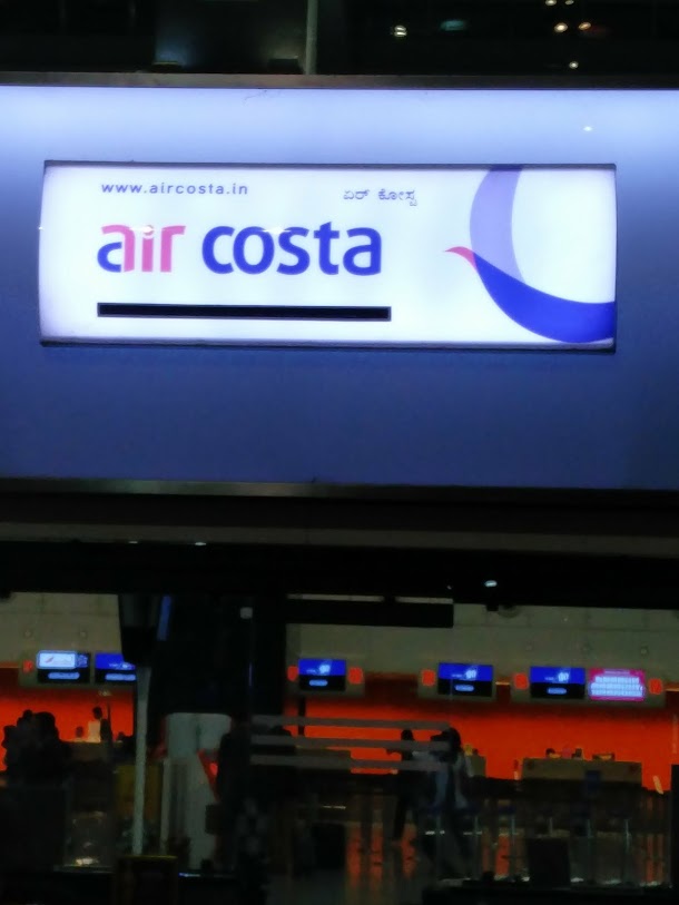
                              Followed by Air Costa

Then the newcomer TruJet.

              Lastly to Vistara another small domestic airline.

Those are the 8 domestic airline counters that I visited.

Then I went to a few international airline counters, starting with the popular German airline Lufthansa.


                     Then Air Arabia.. from West Asia.

                                           Later Air France / KLM from Europe.
There might be more international counters, but I was tired and wanted to just get home.

And finally, our dearest "India's National Carrier" Air India's counter.

Now... Did you observe carefully the 12 pictures posted above?

1) ALL the 12 display boards at airport counters of these airlines, had English prominently displayed. That's because English is the language of business in Bengaluru for white collar crowd, and no one doubts it.

2) Eleven out of the 12 display boards had a small Kannada writing. Kannada is the state official language where this airport is situated, and all the businesses respect the state language by putting a small mention of their name in Kannada. Those who can't read English, will use this. Though for most part it is ornamental in small font as most get their business done with English writing only.

3) Only ONE airline put Hindi in the display. That too with equal size font as English, and positioned above English. Also, this was the ONLY airline which did not put Kannada on the main counter display. And most importantly, this was the ONLY airline whose staff is paid salary using the tax money generated from Karnataka.

I wonder....
  • It is not about for one language or against one language. But how come 11 airlines, including the French, Arabian and German ones understand the basic business etiquette of Bengaluru, but India's "national carrier" does not? 
  • Don't the Air India staff who work at the airport see other boards right next to them daily, and ask themselves.. how come we are ignoring Kannada and putting Hindi on the board, while none of the other airlines, including those from France, Germany or Arabia are doing it?
  • If Air India has to put Hindi display, let them put it. I don't think most people will have any issue with it. If you observed, Air Arabia from UAE is putting Arabic display in Karnataka and no one has issue with it. But Air Arabia is also having common sense to put a prominent Kannada display on the same board!

This is a classic example where business is NOT the primary purpose, but promotion and demotion of languages is... Very disappointed with this irresponsible attitude of Air India and more so because my tax money is paying such people's salary :(